Stara Planina: Serbia's Wild Eastern Mountains
Stara Planina, the wild Balkan range on the Bulgarian border: Midžor peak, the Tupavica and Pilj waterfalls, the stone village of Gostuša and Babin Zub.
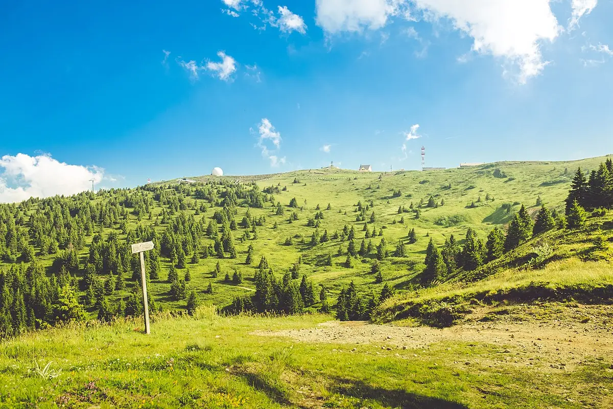
Stara Planina is the wildest, least-visited corner of Serbia, and the one that surprises people most: a long, high, empty range on the far south-eastern border with Bulgaria, where the roads run out, the villages are half-abandoned, and the water falls off the mountain in a dozen places. The name means simply “Old Mountain,” and it is the local name for the western end of the Balkan Mountains, the range that gives the whole peninsula its name. This is the country’s roof, home to Midžor at roughly 2,169 metres, and it is a landscape you have almost entirely to yourself outside a handful of summer weekends.
The honest part first: this is remote. Stara Planina sits a long way from anywhere on the tourist trail, the sights are scattered across dead-end valleys, and you really want your own car to do it justice. Get that right and you are rewarded with the highest ground in mainland Serbia, some of its tallest waterfalls, a stone village that looks a thousand years old, and the kind of quiet the big-name mountains out west stopped offering years ago.
Where is Stara Planina, and how do you get there?
Stara Planina runs along Serbia’s south-eastern edge, forming a natural wall against Bulgaria for something like a hundred kilometres. The gateway town is Pirot, and the nearest city of any size is Niš, roughly 75 km to the west on the Niš-Sofia motorway (the A4/E80). From Niš you can be in Pirot in about an hour and a half; from Belgrade you are looking at the best part of a full day’s drive across the country, so this is a trip you build around eastern Serbia rather than a quick hop from the capital.
The complication starts after Pirot. The waterfalls, the peaks and the old villages are spread through the Visok valley and its side-glens, up gravel and single-track roads to places like Dojkinci, Rsovci, Topli Do and Gostuša. There is some local bus service, but it is sparse and slow, and it will not get you to a trailhead and back in a day. This is a corner of the country where a car is not a convenience but close to a necessity, and where it pays to fill the tank in Pirot, because filling stations thin out fast once you leave the main road.
A good base makes the difference. Most people either stay in or near Pirot for the services and use it as a hub, or head up onto the mountain to the Babin Zub / Jabučko Ravnište area, where the ski centre has hotels and apartments that stay open in summer. Book ahead in winter and on summer weekends; the rest of the time you will rarely struggle to find a bed.
Midžor: the highest point in mainland Serbia
The summit everyone wants is Midžor, at about 2,169 metres the highest peak of the western Balkan Mountains and the highest point in Serbia proper. One caveat worth stating plainly, because you will see it claimed both ways: if you count Kosovo, the country’s highest peak is Velika Rudoka in the Šar mountains, well over 2,600 m. Within Serbia’s undisputed borders, though, Midžor is the top, and it sits right on the Bulgarian frontier, with border markers along the ridge.
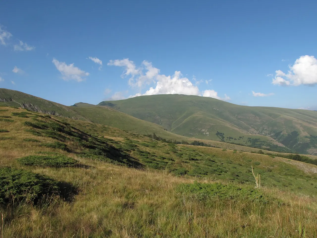
The good news for walkers is that Midžor is not a technical climb. The easiest route starts from the Babin Zub mountain hut near the ski centre and runs roughly 7.4 km to the top, climbing something like 600 metres over open, rolling grassland; reckon on two to four hours up and one and a half to two and a half down, depending on your pace and the weather. It is a long walk rather than a hard one, well within reach of anyone reasonably fit, and the reward on a clear day is a huge view deep into both Serbia and Bulgaria. Two longer, steeper approaches exist too, from the village of Topli Do and from the Bulgarian side, but Babin Zub is the sensible choice for a first ascent.
A word of caution that matters up here. This is a high, exposed ridge with no shelter and notoriously fast-changing weather, and the summit is often lost in cloud even when the valley is clear. Carry layers, waterproofs, water and a charged phone, start early, and be willing to turn back. In winter it becomes a serious snow objective for equipped hikers on snowshoes, not a casual day out.
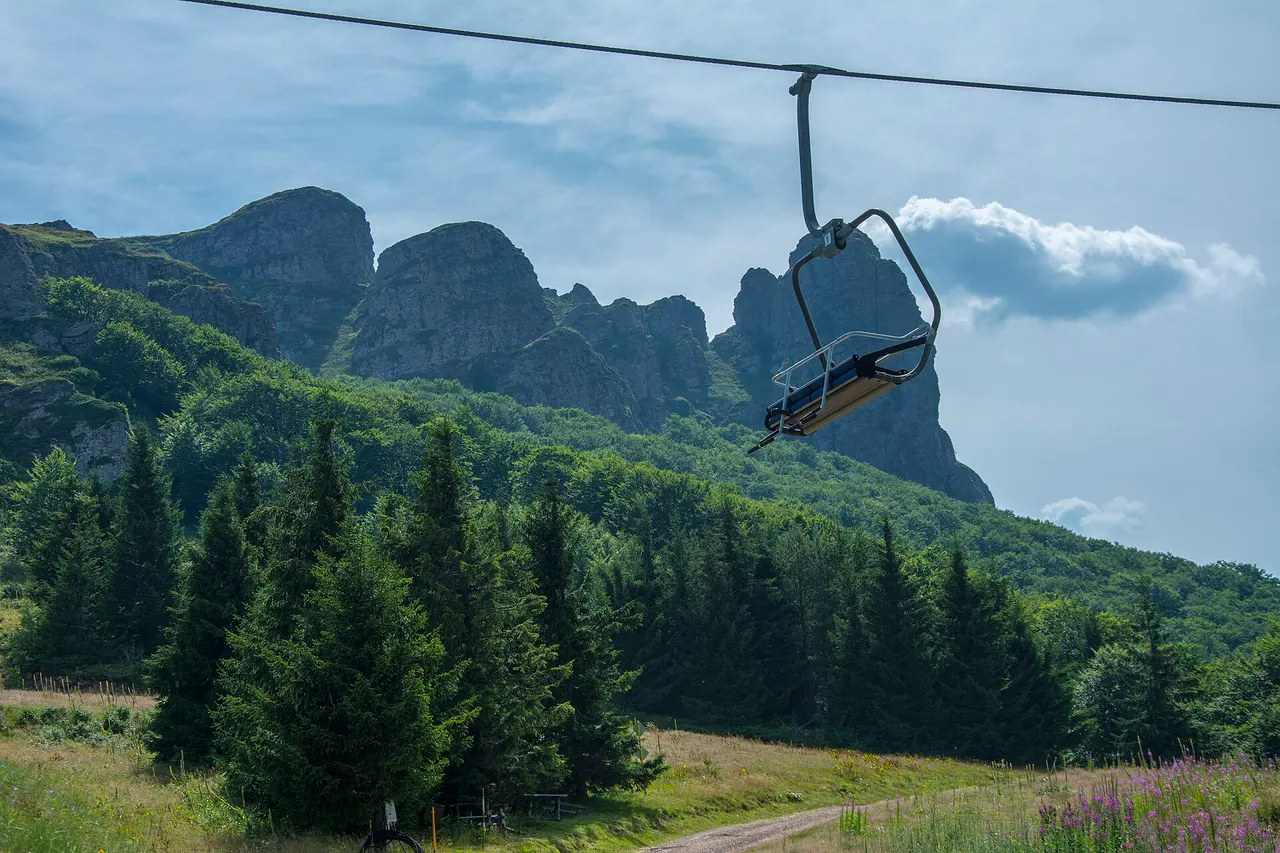
Babin Zub and Serbia’s quietest ski centre
Below Midžor stands the mountain’s calling card: Babin Zub, literally “Grandma’s Tooth,” a cluster of bare rock teeth jutting out of the green slope at around 1,750 metres. It is a genuinely striking natural landmark, protected in its own right, and it lends its name to Serbia’s second ski resort.
The Stara Planina ski centre is a world away from the crowds of Kopaonik. Runs are spread across sectors with names like Konjarnik, Sunčana Dolina and Jabučko Ravnište, adding up to somewhere in the region of 13 km of pistes served by a gondola and chairlifts. It is smaller, higher and far less busy than the country’s flagship resort, which is exactly its appeal for anyone who wants to ski without queues, or who is learning. Lift-and-piste details and prices shift from season to season, so check the current setup before you commit rather than trusting an old figure. Out of ski season the same lifts and lodges turn the area into a handy summer base for the Midžor walk and the surrounding trails. For how Midžor compares with Serbia’s other summits and easier walks, see our guide to the best hiking in Serbia.
The waterfalls: Tupavica, Pilj and the rest
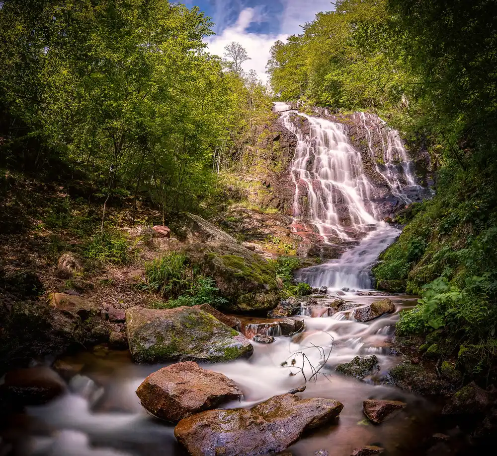
If you come to Stara Planina for one thing in the warm months, make it the waterfalls. The range is riddled with them, dozens catalogued across its glens, and they are at their fullest and loudest in spring, especially May, when the snowmelt is running. Two stand out.
Tupavica is the postcard one. Tucked near the village of Dojkinci at around 1,050 metres, it is a roughly 15-metre curtain of water sliding over a face of reddish, moss-streaked rock, and it is one of the most photographed falls in the country. It is genuinely lovely in summer, and it becomes something else entirely in a hard winter, when it freezes into a wall of ice that draws photographers up the snowbound track to see it.
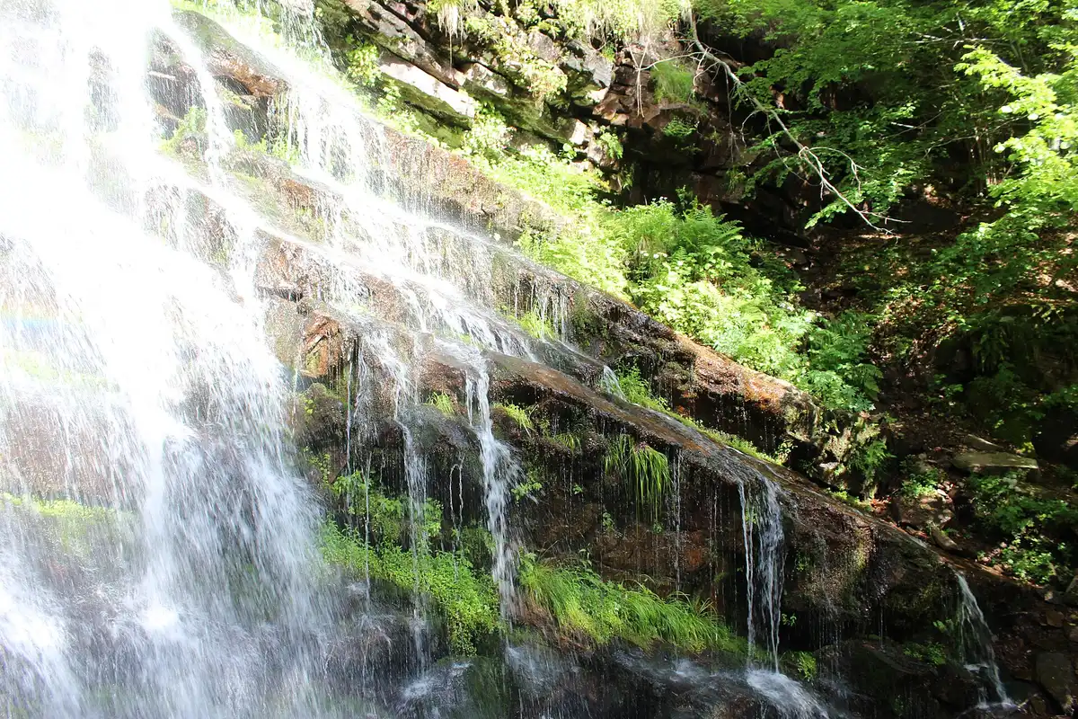
For sheer scale, though, the headline act is Pilj (Piljski waterfall), above the village of Topli Do. Depending on which measurement you trust it drops somewhere between 64 and 65 metres, which makes it one of the very tallest waterfalls in Serbia, and remarkably it was only properly documented by geologists and climbers in 2002, a reminder of how genuinely unexplored this mountain still is. Nearby, in the same wild upper valley, the Čungulj falls plunge another 40-odd metres. Reaching Pilj is a proper hike from Topli Do rather than a roadside stop, so give it half a day, wear boots that can take wet ground, and treat the marked path with respect.
Gostuša: the stone village
Amid all the water and rock sits the human highlight, and it is unlike anywhere else in Serbia. Gostuša, in the Visok region at around 700 metres, is known simply as the stone village (kameno selo), and the name is literal. Its houses are built almost entirely from local stone laid dry, the suvozidica drywall technique, with barely any mortar and roofs shingled in flat stone slabs. Whole cottages, barns and yard walls were raised from what the slope provided, and the effect is a village that seems to have grown out of the mountain rather than been set on top of it.
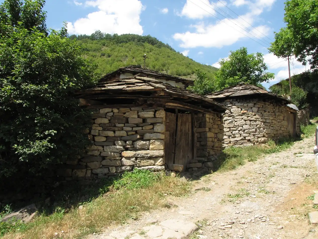
Like most of the mountain, Gostuša is emptying out. It once held something like 1,500 people; now around a hundred remain, most of them elderly, and many houses stand quiet. That fragility is part of why it has been recognised as a protected cultural monument and the subject of a serious conservation effort to keep the old building craft alive. Walk it gently and respectfully; this is a living, if fading, place rather than an open-air museum, and the people who still live here are why it is worth seeing before it changes.
Zavoj lake and the Visok valley
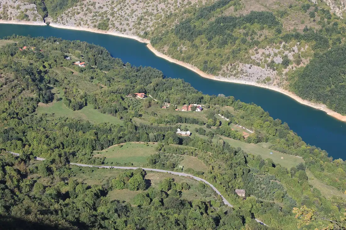
The natural pairing with Gostuša is Zavoj lake (Zavojsko jezero), a long, curling reservoir on the Visočica river just below the village. What makes it unusual is how it formed: a great landslip blocked the valley and dammed the river, drowning the old road and leaving the sinuous blue-green lake you see today, wrapped in steep green slopes. It is a fine spot to break a day of driving, and the view down onto it from the road above is one of the best in this whole region.
All of this sits inside the Nature Park Stara Planina, one of the largest protected areas in the country, which spills over the border to join Bulgaria’s own Balkan reserves. It shelters a rich mix of wildlife and rare plants, and its remoteness is precisely what has kept it wild. You are far more likely to share the trail with grazing sheep and a shepherd than with other hikers, and that emptiness is exactly what you come for.
When to go, and how to plan it
The mountain has two clear seasons and not much in between. Late spring through early autumn (May to October) is the time for everything green: the waterfalls run hard in May, the meadows flower in June and July, the Midžor walk is at its best on a clear summer morning, and the beech forests turn gold in October. Winter is for snow, the Babin Zub ski runs and the frozen falls, but be ready for closed side-roads and serious mountain conditions if you venture off the pistes.
However you time it, plan around the distances. Stara Planina is not a day trip; give it at least a night, ideally two, base yourself near Pirot or up on the mountain, and accept that the driving between sights is part of the experience. It pairs naturally with the rest of the east, and if you are already exploring this side of the country, our guide to nearby Niš covers the region’s main city and gateway. Landscape hunters who love this kind of country should also read up on Tara National Park in the west, the other end of Serbia’s mountain spectrum, and you will find more of the country’s wild corners in the attractions section. If you would rather see it as part of a bigger loop, our Serbia road-trip itinerary shows how the pieces of the country fit together.
Photos
On the map
The map loads on click - to keep the page lightweight.
The map didn’t load. Check your connection and refresh the page.
Distance≈75 km · about 1.5 h to Pirot by car, then more into the villages
- Niš≈75 km · about 1.5 h to Pirot by car, then more into the villagesNiš is the nearest big city and the natural gateway; Pirot is the closest town to the mountain.
Read also
Best Day Trips from Belgrade
Verified · July 4, 2026The best day trips from Belgrade, sorted by real travel time: which are a true there-and-back day, which need an overnight, and how to reach each.
Đavolja Varoš: Serbia's Devil's Town
Verified · July 4, 2026Serbia's Devil's Town (Đavolja Varoš): 200-odd andesite-capped earth pyramids and two acid springs on Radan Mountain, plus tickets, hours and how to visit.
Kopaonik: Serbia's Top Ski & Spa Resort
Verified · July 4, 2026Kopaonik is Serbia's biggest ski resort and a national park: the pistes and lifts, the 2,017 m Pančić peak, summer hiking, spas and how to get there.
Petrovaradin Fortress: Novi Sad's Gibraltar
Verified · July 4, 2026A deep dive into Petrovaradin Fortress: the star-fort design, the 1716 battle, 16 km of underground galleries and the artists who live on the ramparts.