Tara National Park: Drina Viewpoints & Hiking Guide
Tara National Park in western Serbia: the Banjska Stena viewpoint over the Drina canyon, the house on the Drina, hiking, Zaovine lake and how to get there.
Tara National Park is the piece of western Serbia that makes people rethink what the country looks like: a high, forested plateau above the Drina river gorge, where the river coils in a deep green canyon a thousand metres below the cliffs. The one view everyone comes for is Banjska Stena, a rock ledge that looks straight down onto Lake Perućac and the horseshoe bend of the Drina - it is, without much argument, the finest natural viewpoint in Serbia. The trade-off is distance: Tara is about 165 km and a good three and a half to four hours from Belgrade, so this is an overnight, ideally with your own car, not a day trip you squeeze in before dinner in the capital.
Get that logistics part right and you’re rewarded with a couple of unhurried days of viewpoints, bear-country forest, a lake or two and the single most photographed cabin in the country. The rest of this guide walks through planning those two days so nothing feels rushed.
Where is Tara, and can you visit from Belgrade in a day?
Short version: no, don’t try to do Tara as a day trip from Belgrade. The drive is long enough each way that a same-day return leaves you maybe an hour at a viewpoint before you have to turn around, and you’ll have spent seven or eight hours in the car for it. Stay at least one night.
The park sits in the far west, hard against the Bosnian border, with the town of Bajina Bašta as its gateway and management seat. From Belgrade you take the E763 motorway southwest toward Užice, then peel off onto the winding regional road that climbs up to Bajina Bašta and the plateau - reckon on 3.5 to 4 hours with a coffee stop. The mountain section is scenic but slow, so don’t trust a satnav’s optimistic “under three hours.”
A car makes all of this far easier. Buses do run from Belgrade to Bajina Bašta, but the viewpoints and trailheads are scattered up on the plateau above the town, and without wheels you’re leaning on taxis or the occasional local minibus to reach them. If you’re planning a western-Serbia road trip anyway - and Tara pairs naturally with Zlatibor, Mokra Gora and the Šargan Eight railway - hiring a car pays for itself in reach.
Coming from Zlatibor, the big mountain resort just to the south, you’re much closer - roughly an hour and three-quarters by road, which is why a lot of visitors base themselves on Zlatibor’s full infrastructure and treat Tara as a day out from there.
Where to base yourself
There’s no single “Tara town” you sleep in, but a few clear options depending on what you’re after:
- Bajina Bašta - the gateway town on the Drina, lowest and most practical, with the widest choice of guesthouses, shops and restaurants. Good if you want the house on the Drina and the river on your doorstep.
- Perućac - a small village right on the lake at the foot of the plateau, best for anyone who wants to be by the water, near the Vrelo river and the boat jetties.
- Mitrovac - a plateau clearing up in the pines, closest to the main trailheads (including the walk to Banjska Stena) and a good pick if hiking is the priority.
- Kaludjerske Bare - a mid-mountain cluster of hotels and cabins, handy and central to the plateau.
- Zlatibor - not in the park at all, but a full-blown resort an hour and three-quarters away with hotels, spas and restaurants, and a comfortable base if you’d rather have the amenities and drive in.
For a first visit I’d stay a night up on the plateau or in Perućac so you’re out at the viewpoints early, before the day-trippers arrive and before the afternoon haze softens the canyon.
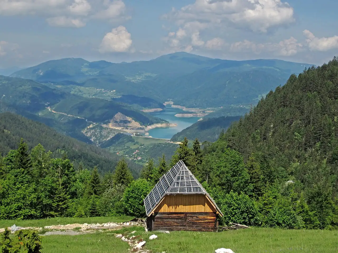
Banjska Stena: the viewpoint that made Tara famous
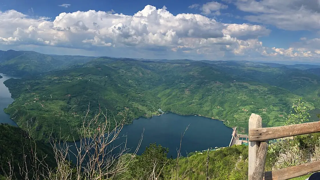
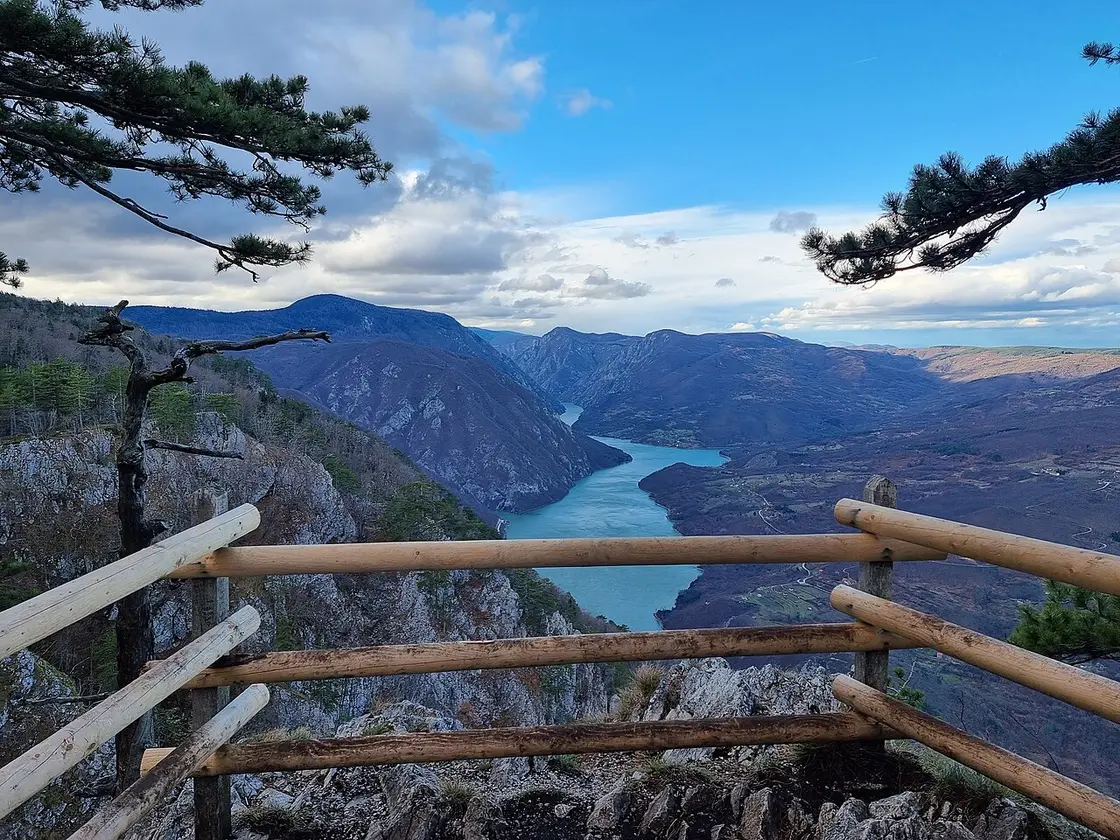
If you do one thing here, do this. Banjska Stena (“the spa rock”) is a railed-off ledge on the canyon rim at 1,065 metres, and it looks out over Lake Perućac, the Drina gorge and the Osat region of Bosnia on the far bank. The river below is a still, deep-jade ribbon - dammed downstream, so it reads more like a fjord than a rushing river - and the cliffs drop away almost vertically beneath your feet. Photos undersell it; the sense of height and space is the whole point.
You reach it from Mitrovac, about 6 km away, and the useful thing to know is that you can drive most of that on a gravel (macadam) forest road and then walk the last stretch to the rim, or you can hike the whole thing on the marked trails (numbered 9 and 9a). The full there-and-back walk from Mitrovac is commonly done as roughly a 10 km round trip in around 2.5 to 3 hours - moderate, well-signed, and fine for anyone reasonably fit, including families with older kids. If you’re short on time or energy, driving to the near car park and walking in is the pragmatic call.
A couple of practical notes. There’s no railing along most of the cliff edge beyond the platform, so keep children close and don’t clamber past the barriers for a better photo - the drop is real. And come in the morning if you can: the light falls into the canyon better, and by midday in summer both the crowds and the haze build.
The house on the Drina
The other image you’ve probably seen of this region - even if you didn’t know where it was - is a tiny wooden cabin perched on a bare rock in the middle of the Drina. This is Kućica na Drini, the house on the Drina, and it sits about 2 km upstream from the centre of Bajina Bašta.
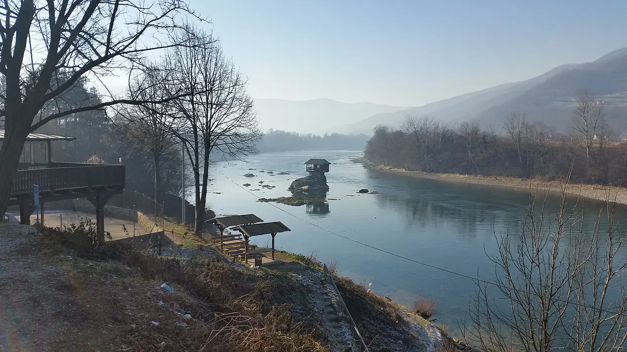
The story is better than the postcard. A group of young swimmers built the first version in 1968 as a place to sunbathe and shelter, using planks the river itself carried down. Over the decades the Drina has flooded and destroyed it seven times through 2019 - and every time, stubbornly, it’s been rebuilt; the cabin standing there now dates from a reinforced 2011 reconstruction. It got its global fame when National Geographic ran a photo of it as a “Photo of the Month” in August 2012, and it’s a fixture of the Drina Regatta, the huge raft party that has floated down this stretch of river every summer since 1994.
You can see it well enough from the bank, but it’s far better from the water: small boats run out from the Bajina Bašta side to circle the rock and get you the head-on shot. There’s no fixed published fare - you arrange it on the spot at the riverbank or through your guesthouse, so ask your host what the going rate is when you’re there.
Hiking, wildlife and the Serbian spruce
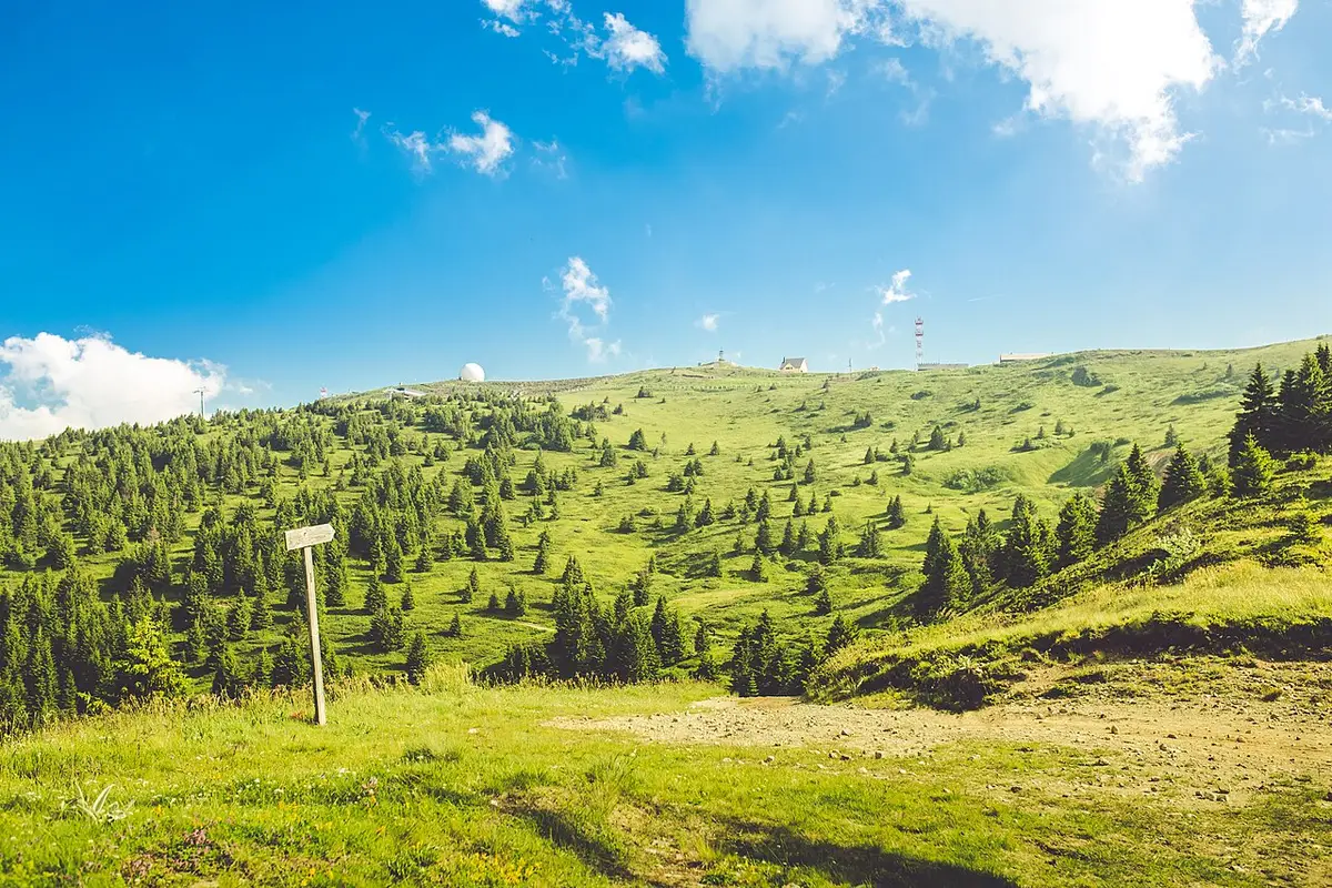
Tara is a genuine walking destination, not just a drive-up-and-photograph one. The park has something like 290 km of marked trails threading through old beech, fir and spruce forest, ranging from easy loops around Mitrovac and Kaludjerske Bare to full-day plateau hikes. The scenery is the reward, but so is the quiet - outside the main viewpoints you can walk for an hour and meet almost no one. If you are weighing Tara against the country’s other trails, our overview of the best hiking in Serbia sets it beside the high peaks and the Uvac canyon.
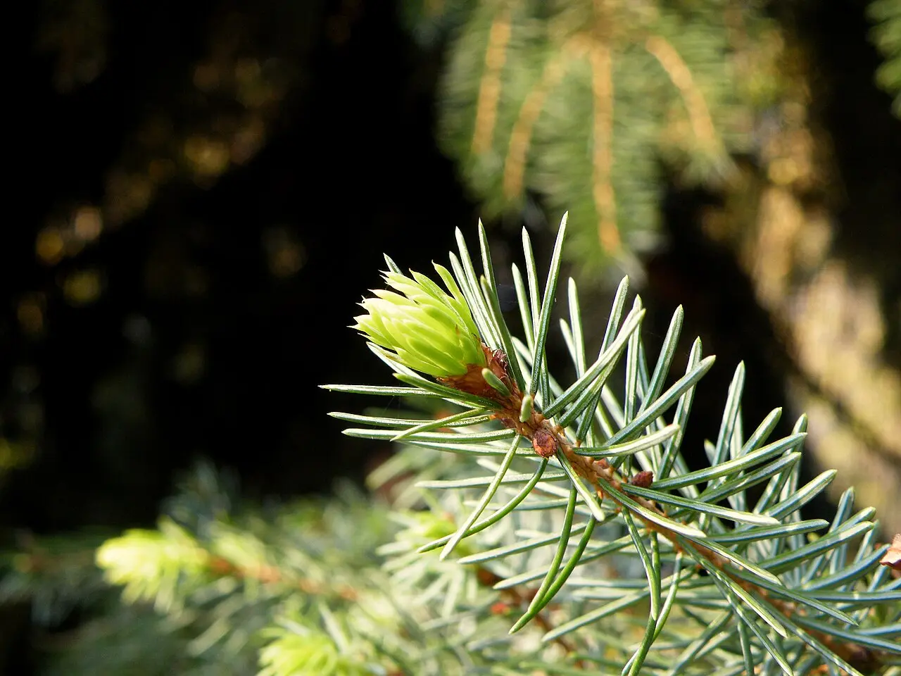
Two things make the forest itself special. First, the trees: Tara is the last real stronghold of the Serbian spruce, Picea omorika, a slender, spire-shaped conifer that the botanist Josif Pančić identified in 1875 and that survives in the wild on almost nowhere but these slopes above the Drina - a genuine relict from the last ice age. Second, the wildlife: this is Serbia’s largest brown-bear population, around 60 animals - roughly four out of five of the country’s bears - along with golden eagles, lynx, roe deer and chamois. You’re extremely unlikely to meet a bear on a day walk (they avoid people), but it tells you what kind of wild country this still is. Stick to marked trails, don’t leave food out at your cabin, and treat it with the respect any bear habitat deserves.
If you’d rather have someone else handle the driving and logistics - and fold in a Drina boat ride or a summer rafting trip - an organised day tour is a sensible way to see the highlights without renting a car.
Lake Zaovine and the Vrelo river
Beyond the canyon and the trails, two smaller sights are worth building in. High on the plateau, Lake Zaovine is a mountain reservoir wrapped in forest - quieter and less visited than Perućac, and a lovely spot to break a drive, swim on a warm day, or just sit by still water at altitude. Some of the finest surviving stands of the Serbian spruce grow around its shores.
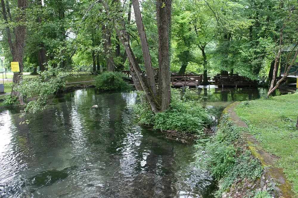
Down at the foot of the mountain near Perućac is one of Serbia’s quirkiest natural landmarks: the Vrelo river, which is only about 365 metres long - one of the shortest rivers in Europe. Because that length happens to echo the number of days in a year, locals call it the “Year River.” It bubbles out of a strong karst spring, runs its brief course past little cascades, and then tips into the Drina over a waterfall a dozen or so metres high. It takes ten minutes to walk end to end, which is exactly the point - a whole river you can see all of at once.
The park has other viewpoints, too, if Banjska Stena leaves you wanting more: Sjenič (1,444 m) has a wooden observation tower, Biljeska Stena (1,225 m) looks over the start of the canyon where the Serbian spruce grows, and Oslusa doubles as a paragliding launch above the Drina valley - all reachable on the plateau’s gravel roads and marked paths.
When to go
The season runs roughly May to October. For hiking and the viewpoints, June to mid-September is the sweet spot - stable, warm weather (summer daytime temperatures sit around a comfortable 21-27 °C at altitude), long days and wildflowers on the meadows. Autumn turns the beech forest gold and is arguably the most beautiful time of all, if a touch cooler.
Winter brings snow, and while nearby Zlatibor and Tara’s own slopes draw skiers, several of the gravel forest roads to the viewpoints become hard or impossible to reach, so it’s a different, quieter trip aimed more at snow and hotels than at standing on Banjska Stena. Whenever you come, bring layers: it’s a good deal cooler up on the 1,000-metre-plus plateau than down in Belgrade, and mountain weather turns fast.
Tara works best as the centrepiece of a wider swing through western Serbia - most people fold in Zlatibor, the Mokra Gora valley with the Šargan Eight heritage railway and Kusturica’s wooden village of Drvengrad on the same loop. If you’re coming out from the capital, our guide to things to do in Belgrade covers the city end of the trip, and you’ll find more of the country’s landscapes and landmarks in the attractions section. For the opposite end of Serbia’s mountain spectrum, the wild, empty Stara Planina range on the far eastern border trades Tara’s polished viewpoints for waterfalls and half-abandoned stone villages. Give it two days, keep the mornings for the canyon, and the four-hour drive stops feeling like a chore.
Photos
On the map
The map loads on click - to keep the page lightweight.
The map didn’t load. Check your connection and refresh the page.
Distance≈165 km · 3.5-4 h by car
- Belgrade≈165 km · 3.5-4 h by carE763 motorway to Užice, then the Bajina Bašta turnoff - an overnight trip, not a day trip.
Read also
Best Day Trips from Belgrade
Verified · July 4, 2026The best day trips from Belgrade, sorted by real travel time: which are a true there-and-back day, which need an overnight, and how to reach each.
Đavolja Varoš: Serbia's Devil's Town
Verified · July 4, 2026Serbia's Devil's Town (Đavolja Varoš): 200-odd andesite-capped earth pyramids and two acid springs on Radan Mountain, plus tickets, hours and how to visit.
Kopaonik: Serbia's Top Ski & Spa Resort
Verified · July 4, 2026Kopaonik is Serbia's biggest ski resort and a national park: the pistes and lifts, the 2,017 m Pančić peak, summer hiking, spas and how to get there.
Petrovaradin Fortress: Novi Sad's Gibraltar
Verified · July 4, 2026A deep dive into Petrovaradin Fortress: the star-fort design, the 1716 battle, 16 km of underground galleries and the artists who live on the ramparts.